
 FrontierDrone Solutions
Pennsylvania aerial field intelligence
Frontier Drone Solutions
Frontier Drone Solutions provides thermal-capable drone services for landowners, municipalities, conservation teams, property managers, and field professionals who need clearer aerial records, better site visibility, and organized deliverables.
How Frontier works
24 to 72 hour review target
Most planned-service requests are reviewed inside a one- to three-day window, depending on scope and workload.
Pennsylvania-first field coverage
Best positioned for Montgomery County and surrounding Pennsylvania properties, municipalities, conservation areas, and project sites.
Operator-led scope review
Requests are reviewed by the operator who has to think through access, terrain, airspace, safety, and usable deliverables.
Deliverable-first planning
The mission is scoped around what the client needs to review, share, compare, or document after the flight.
Disabled veteran-owned
Frontier is a disabled veteran-owned small business built around disciplined field operations and direct client service.
Operator-led review
The person reviewing your request is grounded in field operations, not a generic call-center script.
24 to 72 hour response target
Most planned-service requests are reviewed and answered within 24 to 72 hours, depending on scope and current workload.
Secure deliverable handling
Project files, imagery, and updates are meant to be delivered in an organized, private, client-ready format.
Local Montgomery County roots
Frontier serves Montgomery County and surrounding Pennsylvania communities while remaining available for strong-fit projects elsewhere in the region.
Focused services
Frontier focuses on services that can be scoped honestly, flown safely, and delivered in a form clients can use for planning, reporting, maintenance, review, or stakeholder communication.
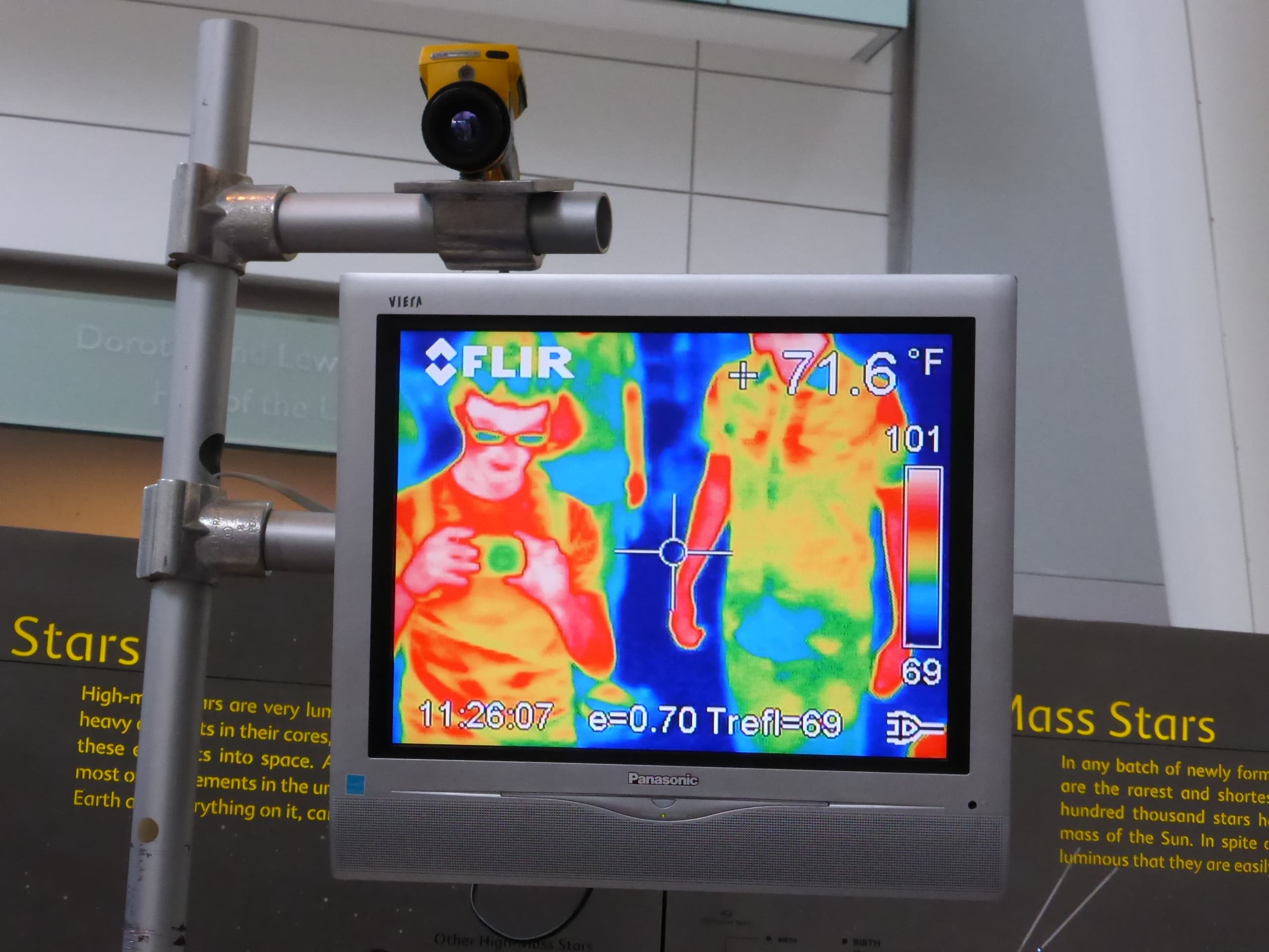
Thermal-capable aerial observation for landowners, municipalities, conservation groups, and animal professionals who need a clearer record of wildlife activity, habitat use, and movement across larger properties.
Best fit
Typical output
Annotated stills and short aerial clips
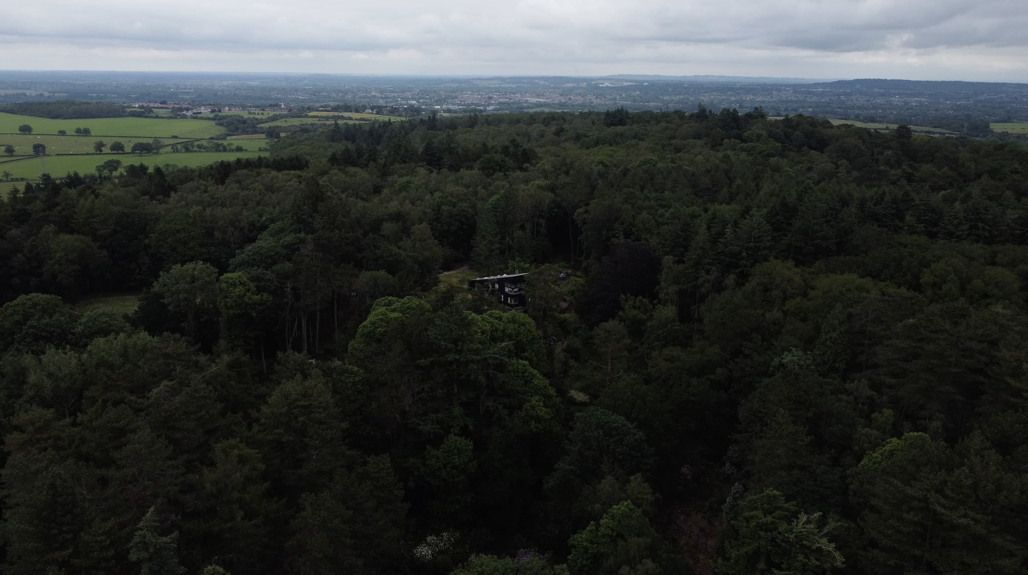
High-resolution aerial records for acreage, structures, access routes, storm impact, vegetation, drainage, and locations that are hard to inspect from the ground.
Best fit
Typical output
High-resolution site overview photos
Thermal-capable aerial mapping and documentation for inspections, land review, storm impact, access planning, and condition records.
Best fit
Typical output
Thermal image and video exports when conditions support useful contrast
Who Frontier serves
Frontier works best for clients who need an aerial record they can actually use for planning, reporting, maintenance review, site coordination, or internal decision-making.
For acreage visibility, storm records, access review, habitat observations, and property documentation that is hard to gather from the ground.
For parks, open space, drainage corridors, field conditions, and visual records that support planning conversations.
For repeatable aerial observation, habitat context, and safer review of larger or harder-to-access areas.
For site overviews, progress context, access-route visibility, and stakeholder-ready aerial documentation.
Local trust signals
Frontier serves Montgomery County and nearby Pennsylvania communities while still reviewing strong-fit projects elsewhere in the state when the scope is clear and the operational fit is strong.
Why Frontier
Frontier focuses on work that can be scoped clearly, flown legally, and delivered with useful records rather than vague promises.
Frontier brings animal-control, land-observation, mechanical, and practical site-access thinking into flight planning and mission review.
The focus is on accurate aerial records for planning, reporting, and review, not inflated claims or emergency-response marketing.
What clients receive
A useful drone job is not just the flight. It is the imagery, notes, and packaged output that help the client explain conditions to the next person in the decision chain and take the next practical step.
High-resolution photos, selected video clips, and organized naming so the material is easy to review later.
Flight-window observations, access notes, and practical context that help the imagery make sense after the job.
Files packaged for owners, agencies, vendors, or project teams who need to discuss what was documented.
How work moves
Choose the service path and describe the location, timeframe, and objective.
Frontier checks feasibility, airspace, weather constraints, access, and safety requirements.
You receive the proposed scope, flight window, deliverables, and estimate.
The mission is completed when conditions support useful, legal, and safe work.
Photos, video, notes, and organized records are delivered for review and sharing.
About the operator
Frontier is built by Dale Porter, whose background spans Army mechanical work, humane and animal-control leadership, IT operations, and field problem-solving.
That mix matters because it creates a business that thinks carefully about access, safety, terrain, record-keeping, and what a client actually needs after a flight.
Frontier is positioned around scheduled documentation and review work where good judgment and useful deliverables matter more than flashy drone footage.
Common questions
The answers below help visitors understand fit, limitations, coverage, and what to expect after submitting a request.
The best fit is a client who needs clear aerial documentation for land, wildlife, property, or site conditions. That includes landowners, municipalities, conservation groups, farms, property managers, and project teams.
The public offer is intentionally built around scheduled documentation and review work. Frontier focuses on useful aerial records and does not overstate what drone imagery alone can prove.
Typical deliverables include organized still imagery, selected video clips, thermal exports when appropriate, and notes that tie the flight to the client’s objective.
Weather, airspace, permissions, access constraints, vegetation, surface conditions, and the purpose of the flight all affect whether the mission is feasible and when it should happen.
Next useful step